

Luggala [Fancy Mountain] [Log an La]
Good walks are even better shared.
O1507 : Luggala (Fancy Mountain) and Lough Tay.
David Quinn Photo source
Overview
Luggala: A Fancy Mountain with a View
Overview
Luggala, affectionately dubbed Fancy Mountain, rises majestically at 595 meters above sea level. Situated in the stunning Wicklow Mountains, it offers breathtaking views and a variety of routes for hikers of different levels. It's the sort of place that makes you shout 'I made it!' once you finally reach the top.
Geology
The geological heart of Luggala is predominantly granite and Quartzite, which contributes to its striking beauty. Its rugged landscape has been shaped by ancient glaciers, leaving behind features that speak of the Earth's dynamic history.
Routes
One popular route is the Luggala Loop, a moderate circular hike covering approximately 8.5 km. This path starts at Glendalough and takes around 3.5 hours to complete, rewarding hikers with stunning vistas and a solid workout.
Summit Features
Upon reaching the summit, expect to be greeted by a rugged rocky outcrop that provides a spectacular panoramic view. Bring your camera — this is definitely 'Instagrammable'.
Terrain
The terrain is a delightful mix of rugged mountain paths, rocky terrains, and grassy slopes, which keeps things interesting! However, wear sturdy footwear to avoid the occasional slip.
Views
From the peak, the sight of Lough Tay and the surrounding Wicklow Mountains is simply unforgettable. Best enjoyed in the spring or autumn, when the air is crisp and clear, it's a scene that begs for a moment of pause – or a short dance!
Hazards
While the views are to die for, do keep an eye on the footing. Slips may occur on the rocky paths, and remember the weather can change quicker than you can say 'jacket potato.'
Nearby Summits
If you're still craving more after Luggala, consider the nearby Wicklow Head (577 meters) for an additional adventure.
Access
Accessible parking is available at the Luggala Estate entrance, though space is limited (be nice and don’t block the gates!). Public transport options are limited, but you can reach Laragh from Dublin with some planning.
Facilities
Toilets are available at the Glendalough visitor centre, and if you're feeling peckish, check out the cafes in Laragh for a quick bite.
History
The name Luggala means 'the hollow of the stone' in Irish, nodding to the region's rich geology. It's steeped in folklore and has drawn pilgrims for centuries, making it not just a beautiful hike, but a journey through time.
So, grab your rucksack and head to Luggala — a fancy mountain indeed! It may just print itself on your memory for years to come.
Happy Hiking!
Explore routes near Luggala [Fancy Mountain] [Log an La]
Walks starting near this hill. Open a route to check its map, distance and full itinerary.
Route planning notes
These notes describe possible approaches. Check a route's map and access information when planning your walk.
Luggala Loop
A popular circular route starting from the Glendalough valley, offering stunning views and a pleasant trek.
Make a day of it, together
Find someone to share the walk with, or organise a day out along a route you like.
Photo Gallery
View all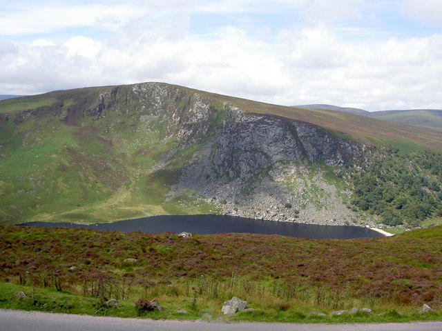 Photo could not load
O1507 : Luggala (Fancy Mountain) and Lough Tay.
David Quinn
Hill facts and local notes
Classifications
Elevation
593m
1,947 ft
Prominence
100m
Coordinates
53.1051, -6.2836
O150074
OS Map
56
At the Summit
The summit is marked with a distinctive rocky outcrop, offering a panoramic view of the surrounding mountains and lakes, providing a perfect photo opportunity.
Terrain & Geology
Luggala is predominantly composed of granite and Quartzite which contributes to its rugged and striking appearance. The landscape also showcases ancient glacial features due to past ice activity in the region.
Views & Scenery
From the summit, you can see the magnificent Lough Tay, the mountains of Wicklow, and on a clear day, as far as the Irish Sea.
History & Heritage
Name Origin
Luggala comes from the Irish 'Log an La' meaning 'the hollow of the stone', relating to the distinct rocky formations found at the summit.
Historical Significance
The mountain has significant historical importance in Irish folklore and has been a site of pilgrimage for centuries.
Getting There & Facilities
Parking
Parking is available at the Luggala Estate entrance, with ample space for a few vehicles (do mind the gates).
Public Transport
Buses from Dublin to Wicklow town connect with local services to Glendalough, although they can be infrequent.
Nearby Facilities
The Glendalough visitor centre provides toilets, while the nearby village of Laragh offers a few cafes and shops for snacks.
Safety Information
Known Hazards
- Potential for slips on rocky paths, unpredictable weather changes, and local wildlife such as red deer, which, while majestic, can be quite shy.
General Safety Tips
- Check weather conditions before setting out
- Carry appropriate clothing and equipment
- Let someone know your planned route
- Take a map, compass, and GPS device
- Carry emergency supplies: food, water, first aid kit, torch
Hills
Some common questions about the hills answered
Are there group walks up Luggala [Fancy Mountain] [Log an La]?
Many walkers use Walkmates to join or organise walks with others. You can check for group walks around Luggala [Fancy Mountain] [Log an La] through the maps
Are there other walkers around Luggala [Fancy Mountain] [Log an La]?
Activity varies by location and time, but Walkmates lets you see whether others have shared walks or shown interest in this area. Find other people through the walking friends search walking friends for Luggala [Fancy Mountain] [Log an La] search or of course create your own walk for Luggala [Fancy Mountain] [Log an La]
Can I organise a walk to Luggala [Fancy Mountain] [Log an La]?
Yes. If there aren’t any walks listed already, you can create a walk and make it available for others to join.
If you're signed up to Walkmates, you can create a walk to Luggala [Fancy Mountain] [Log an La].
How do I find a walk up this hill?
There are often multiple ways to walk this hill, depending on experience and route preference. Walkmates helps you explore walks and routes that others have shared.
Can I suggest a new route up Luggala [Fancy Mountain] [Log an La]?
Yes. You can suggest or create routes to share with others. Walkmates focuses on the social side of walking, so routes are used to help people organise walks and explore areas together, rather than as detailed navigation tools or route libraries.
Other uses really appreciate knowledgeable walkers sharing their routes. Share your favourite route to Luggala [Fancy Mountain] [Log an La] here
The is an error or something incorrect about this hill. How do I let you know?
We always strive to keep the information on Walkmates as accurate as possible. If you find an error, please let us know through the contact form and we'll aim to correct it as quickly as possible
Community Discussion
Comments
Location
![Luggala [Fancy Mountain] [Log an La] location map](https://cdn.walkmates.com/hill-maps/hill-sources/20585/53.10509_-6.28358.png)
Grid reference: O150074
View on OpenStreetMapOpens a map in a new tab, centred on the hill.
Nearby Hills
Mullaghcleevaun
847m
Lugnaquilla [Log na Coille]
925m
Slieve Foye
587m
Slieve Gullion
576m
Slieve Binnian
746m
No comments yet. Be the first.